White Forget-me-not,
White Rochelia
Display all 16 images


Regional Species Conservation Assessments per IBRA subregion.

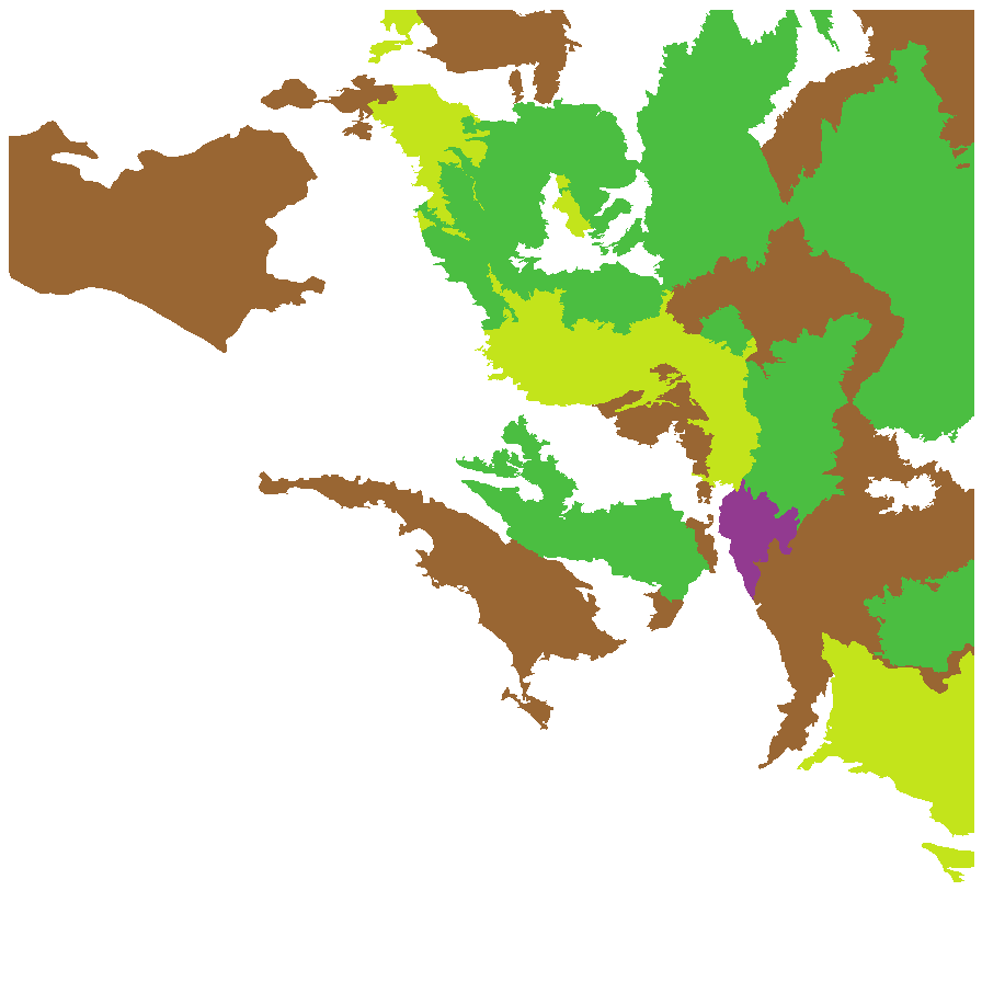
Least concern
Near threatened
Rare
Vulnerable
Endangered
Critically endangered
Extinct
Data deficient
Adelaide
Arkaroola
Ceduna
Coober Pedy
Hawker
Innamincka
Marla
Marree
Mount Gambier
Oodnadatta
Renmark
Wudinna
Keith
Yunta
Display IBRA region text
| Mount Lofty Ranges (FLB01) | Flinders Lofty Block | Data Deficient [old records 1928, Humbug Scrub; checked D Cunningham] |
| Broughton (FLB02) | | Rare (IUCN: RA d(i)) [undercollected] |
| Olary Spur (FLB03) | | Rare (IUCN: RA d(i)) [undercollected] |
| Southern Flinders (FLB04) | | Regionally Extinct [regionally extinct? ] |
| Northern Flinders (FLB05) | | Least Concern |
| Central Flinders (FLB06) | | Least Concern |
| Talia (EYB04) | Eyre Yorke Block | Rare (IUCN: RA d(i,ii)) |
| Eyre Mallee (EYB05) | | Rare (IUCN: RA d(ii)) (Probable Decline) |
| South Olary Plain (MDD01) | Murray Darling Depression | Least Concern |
| Murray Mallee (MDD02) | | Near Threatened [restricted to northern section] |
| Lowan Mallee (MDD04) | | Near Threatened |
| Braemer (MDD07) | | Rare (IUCN: RA d(i)) [undercollected] |
| Murray Scroll Belt (RIV06) | Riverina | Rare (IUCN: RA d(ii)) [not suitable habitat] |
| Myall Plains (GAW01) | Gawler | Least Concern |
| Gawler Volcanics (GAW02) | | Least Concern |
| Arcoona Plateau (GAW04) | | Rare (IUCN: RA d(ii)) |
| Torrens (GAW06) | | Near Threatened |
| Roxby (GAW07) | | Near Threatened |
| Maralinga (GVD03) | Great Victoria Desert | Rare (IUCN: RA d(i,ii)) |
| Barrier Range (BHC01) | Broken Hill Complex | Rare (IUCN: RA d(i)) [undercollected] |
| Curnamona (BHC06) | | Rare (IUCN: RA d(i)) [undercollected] |
| Dieri (SSD03) | Simpson Strzelecki Dunefields | Least Concern |
| Strzelecki Desert (SSD05) | | Least Concern |
| Breakaways (STP01) | Stony Plains | Near Threatened |
| Oodnadatta (STP02) | | Least Concern |
| Murnpeowie (STP03) | | Rare (IUCN: RA d(i,ii)) |
| Peake-Dennison Inlier (STP04) | | Near Threatened |
| Witjira (STP06) | | Rare (IUCN: RA d(ii)) |
| Baltana (STP07) | | Least Concern |
| Sturt Stony Desert (CHC02) | Channel Country | Rare (IUCN: RA d(ii)) [limited habitat] |
| Coongie (CHC06) | | Least Concern |
| Lake Pure (CHC07) | | Rare (IUCN: RA d(ii)) |
| Everard Block (CER03) | Central Ranges | Rare (IUCN: RA d(i,ii)) |
| 6 of 6 subregions | Flinders Lofty Block | Least Concern , Rare , Regionally Extinct , Data Deficient |
| 2 of 5 subregions | Eyre Yorke Block | Rare |
| 4 of 6 subregions | Murray Darling Depression | Least Concern , Near Threatened , Rare |
| Murray Scroll Belt (RIV06) | Riverina | Rare (IUCN: RA d(ii)) [not suitable habitat] |
| 5 of 8 subregions | Gawler | Least Concern , Near Threatened , Rare |
| Maralinga (GVD03) | Great Victoria Desert | Rare (IUCN: RA d(i,ii)) |
| 2 of 4 subregions | Broken Hill Complex | Rare |
| 2 of 4 subregions | Simpson Strzelecki Dunefields | Least Concern |
| 6 of 7 subregions | Stony Plains | Least Concern , Near Threatened , Rare |
| 3 of 4 subregions | Channel Country | Least Concern , Rare |
| Everard Block (CER03) | Central Ranges | Rare (IUCN: RA d(i,ii)) |
Botanical art
Kath Alcock paintings: 3
Prior names
Rochelia maccoya
Rochelia plurisepalea
Maccoya plurisepalea
Allocarya plurisepalea
Common names
White Forget-me-not
White Rochelia
Etymology
Plagiobothrys from the Greek 'plagios' meaning oblique or lateral and 'bothros' meaning a pit, alluding to the scar on the side of the mericarps. Plurisepaleus from the Latin 'plures' meaning several and sepal, referring to the species many sepals.
Distribution and status
Found in the eastern half of South Australia, growing on sandy clay in damp flat at edge of creeks and claypan. Also found in all mainland States. Native. Common in South Australia. Uncommon in Western Australia, Northern Territory and Queensland. Common in the other states.
Herbarium regions: North Western, Lake Eyre, Gairdner-Torrens, Flinders Ranges, Eastern, Eyre Peninsula, Northern Lofty, Murray
NRM regions: Alinytjara Wilurara, Eyre Peninsula, Northern and Yorke, South Australian Arid Lands, South Australian Murray-Darling Basin
AVH map: SA distribution map (external link)
Plant description
Decumbent to procumbent annual herb with many branches, mainly from the base; to 12 cm long, with flowers along the branches; a tap root more or less densely covered with forward-directed, appressed hairs. Leaves densely clustered; opposite and with a broad ciliate sheath at the base in a sparse basal rosette, becoming scattered, alternate and without a sheath on the inflorescences; linear to linear-oblanceolate, to 45 mm long and 3 mm, usually bluntly acute, rarely rounded. Inflorescence terminal, with widely-spaced small tubular white flowers. Flowering between June and November. Fruits are woolly fruit with 2 mericarps. Seed embryo type is spatulate fully developed.
Seed collection and propagation
Collect seeds between October and January. Collect maturing fruits, those turning pale straw colour and contain hard seeds inside. Collect individual fruit or collect the whole plant. Place the fruits/plant in a tray and leave to dry for two weeks. Then rub the fruits gently by hand to dislodge the seeds. Use a sieve to separate the unwanted material. Store the seeds with a desiccant such as dried silica beads or dry rice, in an air tight container in a cool and dry place.